


Dutch mountain trail
The Dutch Mountain Trail in 6 days
Published on 20/08/2026
Dutch???? Mountain??? I can hear you think: the Netherlands doesn’t even have any mountains. You would be right. The Seven Summits that you are described to climb, could more accurately be called hills. Some of the Summits are even located in Germany or directly on the border, while the Vaalserberg is not counted as one of the summits while being the highest mountain in the Netherlands with its 322 meters. The “mountains” were all very disappointing, often not having any view, being next to a road, and there not even being a sign or a bench on the top, just a random crossroads that is supposed to be the top. However, you do not walk the Dutch Mountain Trail for the mountains themselves, you walk it for the trail. While the mountains hardly deserve to be called that, I would say the trail could definitely be defined as a mountain trail. The amount of meters you climb far surpasses the height you actually get to, as the trail rises and falls with the hills of the landscape. Following this path simultaneously gives you amazing views during the hike, even if it is not so on the top of the summits. So even if I would definitely not recommend climbing these mountains, I would for sure recommend walking this trail. In this article, I will describe everything you need to know in order to prepare yourself, according to the experience I had when hiking it myself with my friend Merel.
Contents

Hello! I am Madelief and I wrote this article for you :) I loved exploring my own country in this way, actually taking in our nature instead of travelling by quickly. Since we made some modifications to the standard trail, this is the article I wish I could have read during the planning beforehand!
madelief
The Dutch Mountain Trail is a route through the Dutch province of Limburg, starting at the train station Eygelshoven and ending in Maastricht. This makes it very accessible by public transport. The route is around 100 kilometres, which you can divide into multiple days. The developers of the trail divided it into four parts, but you can divide it however you like, depending on your circumstances and accommodation. We chose to camp along the way, carrying all of our supplies on our backs. For this reason and so we could take more time to enjoy it, we spread out the route over six days. More on that later. The route also passes through some towns, so if you want some more luxury, you can choose to spend the night in hotels or B&B’s. Going to your accommodation and back to the trail again will add some kilometres to your day, so keep that in mind.
The route follows the hilly landscape of Limburg, occasionally crossing the border into Germany and Belgium. It is based on the idea of the Seven Summits: the highest mountain of all seven continents. For this, they took the seven steepest “mountains” in Limburg and made Limburg’s own Seven Summits. How they determined which ones were eligible, I have no idea. Very confusing, as the Vaalserberg wasn’t even one of the Seven. There are trails for each summit, but I would not really recommend those. When doing the Dutch Mountain Trail, you will automatically climb the Seven Summits, and some other mountains as well. As I said before however, the trail in between is more worth it than the mountains themselves. It will take you on mountain trails, but also through meadows, farmlands, forests and towns. We were doubting whether to take mountain hiking shoes, since we heard there was also a lot of walking on asphalt roads. Trail shoes, in between sport and mountain shoes, were recommended. For the first and the last part there were indeed a lot of asphalt roads, but we were very glad to have brought our mountain shoes as most in between was unpaved and there were some very steep paths.
We took the Dutch Mountain Trail book, which I would really recommend. Aside from fun facts, this had a map and a detailed description of the route, you can read every turn. You can also download the route on your phone, but this costs a lot of energy and you have to look at your phone the whole time. Having the route description worked perfectly for us. Everything was described in detail and so we were often assured that we were on the right path. Since we had a version from 2022 and we hiked in 2026, some descriptions weren’t relevant anymore: a sign had been taken down or a road was now paved. This was however easily found out by following the next clue. Only the part between Gulpen and Mheer was written a bit more cryptically, but we figured it out every time. So definitely recommend buying that! (please sponsor us).
What is it?


Camping
We brought a tent and camped along the way. For this, we bought everything lightweight: tent, sleeping bag, mat, a small gas burner and everything to be able to cook. We also both had a big backpack, made to hike with for longer amounts of time. It is very important that you have a backpack that hooks around your hips, so your legs carry most of the weight instead of your back. This made the trip a lot heavier, but also very fun. It is very special to be able to carry everything you need on your back, pack up your entire living, bring it with you for an entire day, and set up camp in the evening. A lot of campers also chitchatted with us about our hike, which was very fun. On the other hand, we were really stinking up the place as we only brought two outfits for less weight and were sweating in them all day. Sometimes, people even loaned us chairs or gave us food because we looked so tired haha. Our backpacks weighed around 15 kilograms, some more if we were carrying food for the next day as well. We would go to the supermarket whenever this was close to our route, as this minimized the extra weight we would have to carry. Subsequently, we lived mostly on chocolate spread, as we did not want to buy too many different things. The walks to the campings also added a few extra kilometres every day. If you are planning on camping along this trail and haven’t done so before, I would really recommend doing a two-day trip with the tent. This allowed us to get the feel of how it would be and what we needed to make it a success. These are things you can’t be told, but have to experience: such as your backpack feeling extra heavy in the morning, but that this will get better when walking for a while. It is also important for your body to be able to adjust. Even with hiking experience, the extra kilos add a different experience. If you do not give your body time by building it up over time before doing the longer hike, you will increase risk of injuries.
Since the campings are not evenly spread out and we did not see any blogs online who did what we did, it was difficult to figure out the perfect route. In the end, we landed on the route described below. It was nice to start the first few days with a few less kilometres, as that makes it possible to warm up. Once your body is adjusted, the hiking will come easier. To find the campings, we used this site. This was really amazing, as it shows all campings along the route. It can also be used for hotels or B&B’s. This site shows how many kilometres have passed in what point on the route. This was very helpful in planning the route. However, the amount we logged on Strava was always more than we planned for. Walking a bit the wrong way, walking to the camping or supermarket and not exactly accurate predictions all added to the amount of kilometres per day. Next, I will detail what we actually walked each day.
Hike in 6 days
Expectation: 11 km
Strava: 10 km
Vertical meters: 201
The trail starts at the station in Eygelshoven. Very convenient, as you can reach it by train. Make sure you go to the toilet in the train though, as there is only one track and nothing else in the station, but it is a nice place to start the hike as you can immediately walk into a trail instead of walking on a paved path. Even though a lot of the route the first day is still in an inhibited area, you hardly notice it when you walk through the woods. However, a relatively large part this day is on a paved path, so be prepared for that. This day, you also climb up the first summit of the seven: the Wilhelminaberg. The climb was steep with some loose rocks, nicely through the woods. However, the top was immensely disappointing. There is a snowworld on top and everything is asphalt, all in all very ugly. But as I said before, the summits were not the best parts and we enjoyed the hike. It was very nice to have a shorter day to start, as this helped us and our bodies get used to the walking and the heavy backpack. When we arrived in Kerkrade, we took the bus to our hotel. We slept in Abdij Hotel Rolduc, which is a hotel in an old abbey. We did this, as there are no campings in the first part of the route. It was also nice to have a gentle start. So we could start the rest of the trail warmed up and well-rested!


Expectation: 17km
Strava: 18 km
Vertical meters: 202
On day 2, we started by going to the supermarket in Kerkrade to get food for the day. Then we started the hike to Vaals. Again, there were a lot of paved paths in between this day. Luckily, that will change on day 3. It was a really nice day, which included a part between all these windmills in the meadows, which was really fun. We ended on the next summit: the Schneeberg. This was again a really nice route through the woods towards an immensely disappointing checkpoint which was literally just a crossroads in the woods, no sign, view or anything. We took a different route downhill, as we were going off route in order to find our camping. We took a grown-over path that turned out not to be a path and immediately got lost, ending up on a golf course. Fortunately for our spirits, we finally found a way down and found the camping! We stayed at Hoeve de Gastmolen. Here we met some other people that were walking the same trail, which was really fun. We had a culinary dinner of noodles with tofu and broccoli and went to bed early. Tip of the day: if it does not look like a path, it probably isn’t.


Expectation: 12km
Strava: 17km
Vertical meters: 379 (but I think Strava is scamming me cause it felt like a lot more)
Again, we started with the supermarket in Vaals. Afterwards, this day was almost only unpaved trails through woods and meadows! We also climbed the Vaalserberg, the highest mountain in the Netherlands, which ironically was not one of the seven summits. There were a lot of vertical meters on this one, which combined by it being a lot further than we expected made it a hard day. We also had a near death experience: while walking through a meadow full of cows, Merel decided to mention that someone was trampled to death by cows near Vaals a few years ago. Luckily, we made it through. Always remember not to get too close or separate the herd. We walked parts through Germany as well and it was a nice route. In the evening, we stayed at Camping VandenBooren, which was really windy but did have a nice field for hikers. We had some wraps filled with beans, corn and tomato, which were actually really nice with a spice packet. Then we piled on everything we could find to stop too much wind from coming in and went to bed early again!


Expectation: 20km
Strava: 22km
Vertical meters: 534
On day 4 we started very early as we miraculously woke up fresh at 7am. This turned out to be very well-timed, as this day was a bit longer than expected as well. It was a nice, mostly unpaved route, through a lot of meadows and some woods with a lot of fallen trees. After the first few kilometres we passed Wahwiller, which had a vending machine with fresh fruit! Tragedy struck however: they also have a soft ice cream machine, but this was closed until 12am so we were too early :(. We also climbed Eyserbos, which was just as disappointing as the other summits. The Gulperberg was pretty nice however, with some benches on top. While the route was nice, it was also very confusing. We thought maybe someone else wrote the instructions in the book for this part of the route (starting from Gulpen), as it started becoming more and more cryptic. It went completely wrong in a meadow soon after passing the Gulperberg, as the book stated just to find your own way down, around on the right or on the left. We had been wandering around for a while until we found out we should have just turned left and kept walking all the way down this way. In the end, we found our way and arrived at Camping Oosterberg in Eperheide. From here, we took the bus to Epen and treated ourselves to a well deserved dinner in the pizzeria restaurant Bij Giuseppe! You could also order pizza to the camping, but we took this chance to get provisions in the supermarket as well.


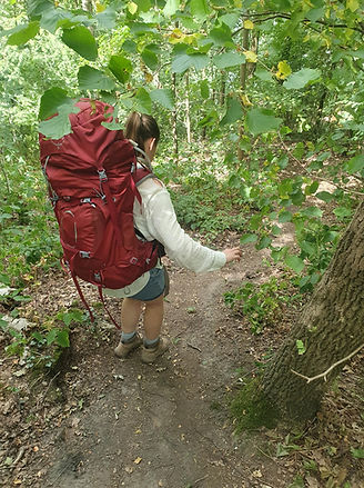
Expectation: 21km
Strava: 24km
Vertical meters: 528
I didn’t take many notes of this day. It was pretty tough, as there was a lot of climbing involved as you can see in the vertical meters. This day included two of the seven summits, which both were not really impressive. It was a really nice walk through nature though. If you’re going in summer like us, make sure to bring enough sunscreen and a hat, as there were a lot of parts walking through meadows, in the full sun. The parts in the woods were a lot cooler. All in all, a nice day. We ended on the camping de Mescherhei. Here, we ate our dry packets of food as we wanted to test those, and they were better than expected! But even better were the nice people on the camping, who saw how tired we were (and the amount of blisters Merel had) and decided to give us some soup!


Expectations: 18km
Strava: forgot to turn it off in time
Vertical meters: 222
This was by far the hardest day for me. Obviously, we were already tired, but we still had a long way to go. This was the hottest day of them all, with a burning sun and a high humidity, which meant we were sweating like crazy. There is a ferry on this route, which runs only in certain seasons. You need to check this beforehand, because if it is not running that means you have to add on 8 kilometres. Since we were nearing Maastricht, a lot of the route was paved and not really in nature anymore. This made it even hotter as well, since we had less trees to shield us from the sun. We were doing pretty good, until it was time to climb the last of the seven summits: d’n Observant. The path that we should have taken, was blocked with so many fallen trees that there was no way to pass it. We decided to take a shortcut, which turned out to be disastrous. Since we didn’t want to back down after the first one, we did the climb to the top right through the bushes, dragging ourselves and our backpacks up by tree roots on our hands and feet as it was too steep to even stand up straight. Covered in scratches, we finally made it up. You guessed it, barely any view. After this exertion to get up, I was in a very bad mood when it turned out we had to cross a marl quarry. All in all, we did end up making it to Maastricht eventually and rewarded ourselves with the long promised soft ice cream. We got groceries and made it to the city camping of Maastricht, where we could rest. Again, we probably looked so pathetic, that some really nice people on the camping gave us their incredible chairs and some snacks, so we could really enjoy our rest. We ate some burgers and marvelled at how we completed the whole trail!!!


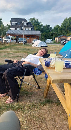
You could also choose to take the train home after arriving in Maastricht, as the trail officially ends at the station. We decided on one more night, for very important plans the next day… We spent the whole day in the spa, finally letting our muscles relax. It was amazing. All in all, a beautiful route, that can give you some hard times but really has you feeling accomplished at the end!